

After entering May and June, the weather in the northern and southern China diverged, presenting two completely opposite situations.
From May 1 to June 15, heavy rains and even floods hit many parts of southern China. The average rainfall in Fujian, Guangdong and Guangxi reached 621 millimeters, the highest in the same period since 1961, according to the National Climate Center (NCC).
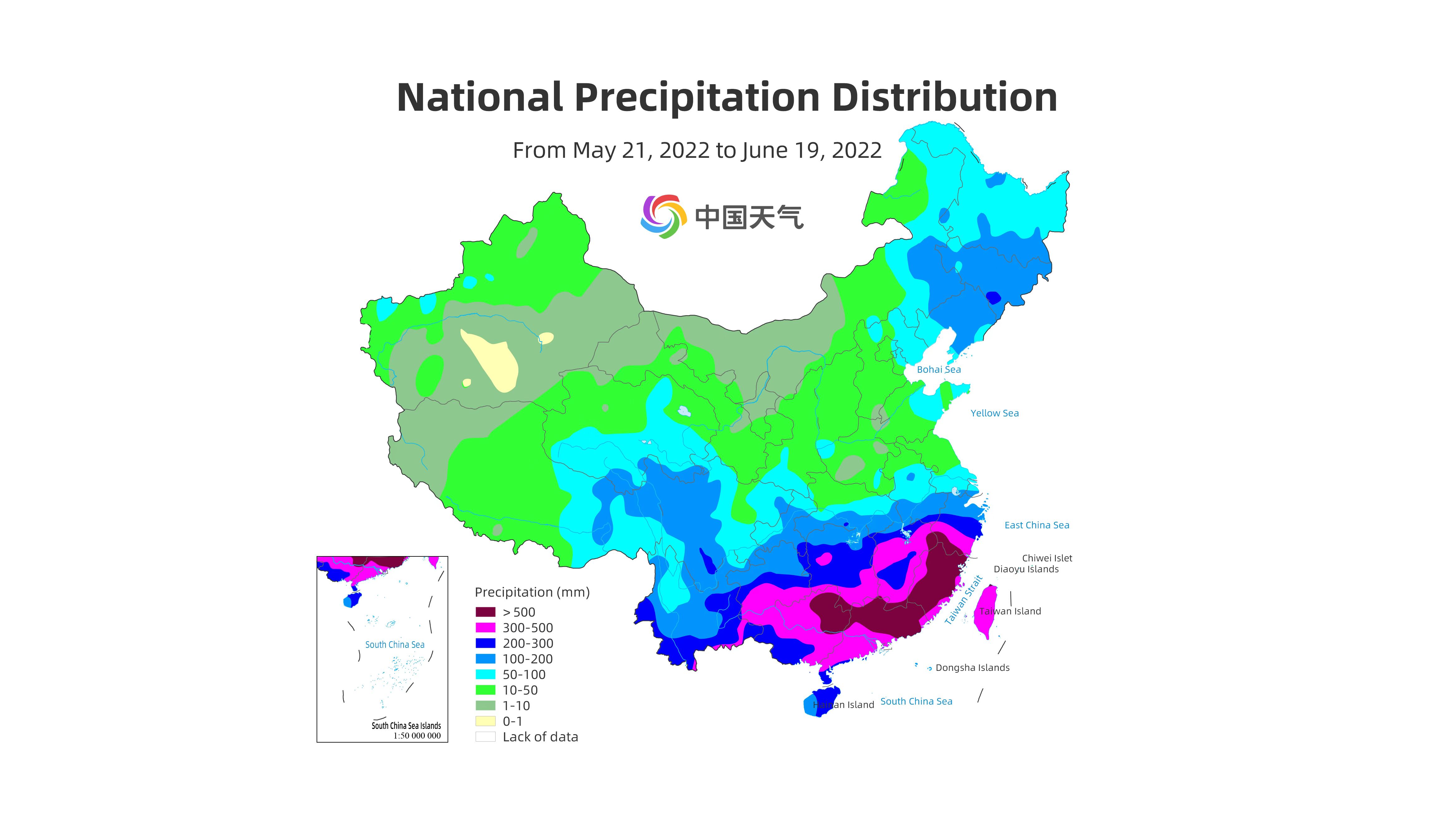
Map of China's national precipitation distribution from May 21 to June 19. /Weather China
Meanwhile, a regional high temperature event occurred in many parts of the northern China after June 15. In many areas, the highest temperatures have already exceeded historical extremes for this time of year.
Not only China, but also Europe, the United States, Brazil, India and other places have experienced a series of rare heat waves, abnormal rainfall and other extreme weather.
In recent years, extreme weather events have occurred more frequently, and the impact of global warming cannot be ignored. According to NCC, the heavy rainfall in southern China is caused by the increasing instability of the atmospheric circulation system due to global warming and the ongoing La Nina event.
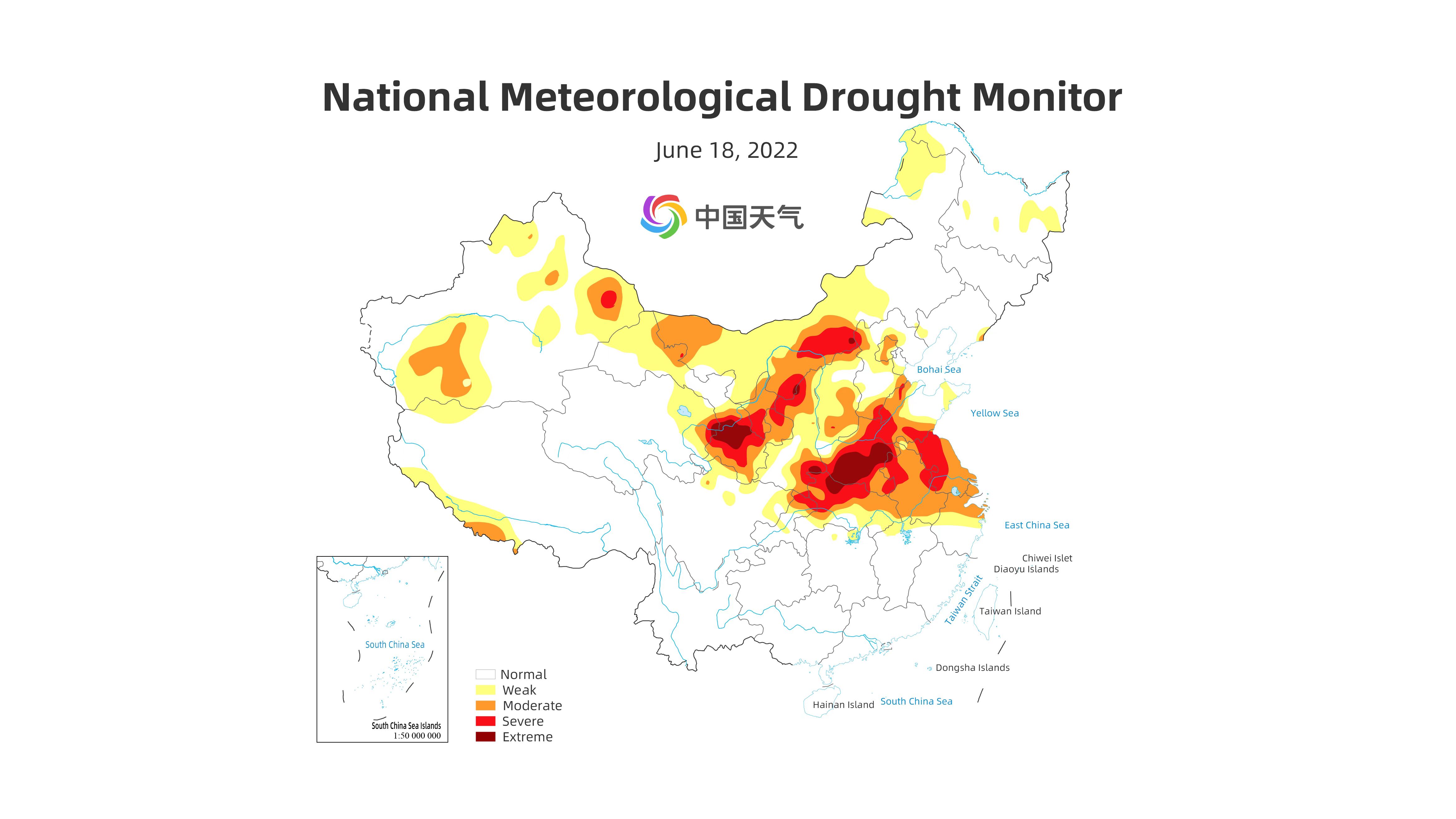
Map of China's national meteorological drought monitor on June 18. /Weather China
The latest forecast from the World Meteorological Organization (WMO), issued on June 10, gives a 50 to 60 percent chance of La Nina persisting until July or September. The U.S. National Oceanic and Atmospheric Administration’s Climate Prediction Centre has forecast a 51 percent chance of La Niña in early 2023.
The occurrence of two consecutive La Nina winters in the Northern Hemisphere is common, but having three in a row is relatively rare. It would only be the third “triple-dip La Nina” (three consecutive northern hemisphere winters of La Nina conditions) since 1950, according to WMO.
The current La Nina event started in September 2020 and continued through mid-May 2022 across the tropical Pacific, and it has strengthened since March 2022.
La Nina refers to the large-scale cooling of the ocean surface temperatures in the central and eastern equatorial Pacific ocean, coupled with changes in the tropical atmospheric circulation, namely winds, pressure and rainfall. According to Nature magazine, more La Nina events would increase the chance of flooding in southeast Asia, boost the risk of droughts and wildfires in the southwestern United States, and create a different pattern of hurricanes, cyclones and monsoons across the Pacific and Atlantic oceans, as well as give rise to other regional changes.

The occurrence of two consecutive La Nina winters in the Northern Hemisphere is common, but having three in a row is relatively rare. /VCG
So far, the impact of La Nina events on the weather in China is more obvious. “The subtropical high in China tends to be northward, which indicates that in the coming months, the rainy season in the northern China may be earlier, and the typhoon activity in the south may be relatively more,” said Hu Xiao, Chief meteorological analyst of Weather China, the China Meteorological Administration's online weather service.
In the background of La Nina events, the overall rainfall characteristics of China during the flood season this year are likely to be more rains in the northern China and South China, less rain in the regions from the Yangtze to Huaihe rivers, and in the regions south of the Yangtze River, he added.
(If you want to contribute and have specific expertise, please contact us at nature@cgtn.com.)