


Data solidarity: What we can learn from China-Nepal border disaster
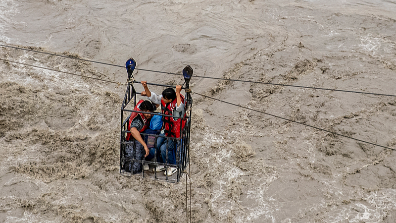
Residents commute across the Trishuli River on a newly installed zipline in the aftermath of flash floods at Bidur in Nepal's Nuwakot district, September 3, 2026. (Photo: VCG)
At 10:52 a.m. on August 26, a mass of glacier broke away from a high slope in Nepal's Langtang region. Seven minutes later, it reached Gyirong Port on the Chinese side of the border. It had fallen some 3,300 meters and traveled some 22 kilometers.
The United States Geological Survey recorded the seismic energy released by the collapse as equivalent to a magnitude-5.2 earthquake. By the time the mud settled, roughly 0.7 square kilometers of the port area had been leveled.
The human toll is still being counted.
As of 6 p.m. on September 4, 31 people had been confirmed dead and 531 remained missing in the disaster-hit Gyirong County, southwest China's Xizang Autonomous Region, according to the On‑site Emergency Rescue Command Headquarters for the disaster.
Nepal police has reported 1,342 deaths, with 4,898 people still missing as of 5 a.m. on Saturday.
Two neighbors, one mountain, one event. From onset to arrival: seven minutes.
The slower clock
Set those seven minutes against the timetable of our response.
In July 2025, after floods on the Bhote Koshi swept away the Miteri (Friendship) Bridge at Rasuwagadhi, China and Nepal publicly agreed to share real-time cross-border information on floods, landslides and glacial lake risks.
In May 2026, officials met in Kathmandu, where Nepali hydrologists asked for data on glacier movement and water levels on the Chinese side.
Between late May and early June, a joint Chinese scientific expedition carried out fieldwork along the transboundary rivers, and a team from Chang'an University established a preliminary field monitoring system built around seismic signals.
In July, China presented MAZU (Multi-hazard, Alerts, Zero-gap, Universal), the early-warning solution it has developed for the Global South, at the fifth Trans-Himalaya International Cooperation Forum in Nyingchi. The forum drew delegates from 29 countries and regions, including Nepal's deputy speaker.
Every one of these was a step in the right direction. On the morning of August 26, the disaster struck.
That gap is not evidence of bad faith. It is simply the ordinary pace of institution-building, a pace set by protocols, mandates, budgets and the slow accretion of trust.
The trouble is that disasters do not wait.
A deficit we share
When disasters like this one are reported, the habit is to look for someone to blame. The more useful thing is to look closely at what actually failed. What emerges is not a story of one country withholding something from another.
Consider what Nepal's own disaster officials have said publicly. Pradip Kumar Koirala, a coordinator at Nepal's National Disaster Risk Reduction and Management Authority, told the Chinese news outlet Jiemian that neither side received any effective warning before the disaster.
Between the two countries, he said, there are presently only framework and intent documents at the leadership level; the concrete operational mechanisms remain to be built.
Of the 10 hydrological stations in the affected area, six were destroyed outright by the flood. Village-level safety officers, he said, can only watch with the naked eye, having neither equipment nor funding.
The information barrier on either side of the border is, in his words, the chasm that joint prevention must cross.
Read that carefully. This is not a charge of concealment. It is a description of a capability deficit – and a shared one.
Nepal's shortfall is plain: instruments it cannot afford, stations a single flood can wipe out and a last mile that depends on someone standing on a hillside looking upstream. China's shortfall is less obvious but no less real.
It has satellites, seismic arrays and modeling capacity. What it does not have is a reliable way to anticipate the moment when a mass of ice and rock, perched above 5,000 meters in terrain too steep and too high for routine ground surveys, will let go.
That is an unsolved problem in geophysics, not a failure of vigilance in any one country.
Two neighbors, then, exposed to the same hazard, each holding part of the answer, neither holding enough.
This is where the blame frame does its real damage. It converts a shared vulnerability into a bilateral grievance. It buys outrage and costs time, the one thing a disaster is least willing to give.
Asking who failed is an understandable instinct, and in most domains, it is the right one. Here, it is the wrong one, and it is worth being precise about why.
The source zone lay above 5,200 meters. No significant rain fell in the catchment that day. The event began with ice and rock, not with water released by any structure.
Even a monitoring network far denser than anything either country operates would have detected the first signs of failure in minutes rather than hours. That is enough time, perhaps, to clear a riverbank, but not to evacuate a valley.
None of this makes monitoring futile. It means the question worth asking is not who knew what and when, but what we would have had to build in advance to have had even those few minutes.
Early warning as a public good
There is an answer, and part of it already exists.
MAZU is the early-warning system developed by the China Meteorological Administration in support of the United Nations' Early Warnings for All initiative.
It combines satellite observation, radar, numerical forecasting and artificial intelligence, and it is delivered as a cloud service rather than as hardware a recipient country must buy and maintain for itself. More than 40 national meteorological agencies now use it.
Customized versions are running in Pakistan, Ethiopia, the Solomon Islands, Jordan and Sri Lanka. Cloud nodes in Singapore and Cairo bring South Asia, Southeast Asia, the South Pacific and Africa within reach, and China has said it expects to extend the system to 30 countries within five years.
The detail that matters is a small one.
The joint China-Pakistan early-warning platform carries a dedicated module for glacial lake outburst floods, or GLOFs, that tracks hydrological change in high-mountain terrain with precision. It was built for the Karakoram. The Himalaya obeys the same physics.
That points to a concrete proposal: pair the GLOF capability already proven in the Karakoram with the seismic monitoring network already piloted along the China-Nepal transboundary rivers, and build from them a joint cryosphere early-warning platform that is jointly governed and jointly funded, drawing on the satellite and modeling capacity China already shares through MAZU.
Nepal would gain instruments and lead time it cannot presently afford. China would gain eyes on terrain it cannot presently survey.
Both would gain something harder to measure and worth more: a standing mechanism. When the next disaster comes, cooperation does not have to be improvised in the middle of it.
Which brings us to the principle underneath all of this, and the one I would press hardest. We have grown used to treating data generated within a country's borders as an attribute of sovereignty, something to be granted, withheld or traded.
In lowland geopolitics, that instinct has a certain logic. At 5,000 meters, in a warming mountain world where the failure of a single slope becomes a catastrophe in two countries within 10 minutes, it is a luxury we can no longer afford.
Data held upstream is not a sovereign privilege. In these mountains, it is a lifeline, and it should be governed as a public good.
The Third Pole as a test case
The stakes reach well beyond one border crossing.
The Qinghai-Xizang Plateau has warmed by about 0.35 degrees Celsius per decade since 1961, well above the global average. Nepal has lost close to a third of its glacier ice in three decades, and the rate of loss over the past decade was some 65% faster than in the decade before.
Glaciers that thin and retreat also destabilize the rock and moraine around them, and the failures that follow are increasingly cascading: one hazard triggering the next, across the very boundaries our institutions were built around.
The Westphalian settlement assumed that the world could be divided into territories and that what happened inside each was primarily its own affair.
Cascading hazards of the cryosphere are a direct refutation of that assumption. They do not recognize the unit of account. They cross borders, need no visa, and arrive in minutes.
How we respond is therefore a test of something larger than disaster management. It is a test of whether a system of sovereign states can learn to govern shared risk at the speed the risk actually moves.
The Third Pole is where that question will be answered first because that is where the ice is moving fastest.
Coda
Since August 26, China has shared satellite imagery, hydrological data and barrier-lake warnings with Nepal, sent relief supplies and tunnel-rescue specialists, and flown DNA identification experts to Kathmandu.
Little of this has been widely reported, which is in the nature of relief work. But it points to the same principle: capability that stops at the border is worth less than capability that crosses it.
At 10:52 the glacier let go. At 10:59 it arrived.
We cannot make disasters slower. We can make our institutions faster.